
I headed out in the pre-dawn darkness. My brief stop in Tupelo for coffee and a pastry made me wish I had some time to spend there. This wish is shaping up to to be the recurring motif of this trip. I had a lot of places to be today, and I didn’t even bother hunting for the historic marker outside the shotgun shack where Elvis Presley was born. I was headed to Jackson, loudly singing along with Johnny Cash and June Carter.
When I breeze into that city, people gonna stoop and bow
All them women gonna make me teach ‘em what they don’t know how
I’m goin’ to Jackson, turn loose my coat
I’m goin’ to Jackson
Goodby was all she wrote
I didn’t expect any stooping or bowing, and I had no designs on the women there. I was only allowing myself what seemed like a ridiculously short visit, even though Jackson fascinated me.
Jackson is the capital city of the most conservative state in the country but it’s elected a socialist mayor: Chokwe Lumumba 1 . Coming from Burlington, a city in a very different kind of state, but one also known for its socialist mayor (Bernie Sanders), I was curious how Jackson would look and feel.
Jackson also was the scene of important events in the Civil rights movement that I was eager to learn more about. This was the place where scores of freedom riders were thrown in jail in 1961 for using the “wrong” bathrooms and waiting rooms at the Greyhound station. Medgar Evers was assassinated here in 1963 (his killer wasn’t convicted until 1994). In 1970 Jackson State students were gunned down protesting the Vietnam war (the white protesters killed at Kent State the week before captured most of the nation’s attention. There’s no Crosby, Stills and Nash song about Jackson State).
I had no illusions that my short visit would give me a sense of what Jackson is like for those who live here. I barely had time for a quick take-out breakfast from Sugar’s Place (a soul food restaurant that knows its biscuits), and a short,brisk walk around the city. It was a sunny, warm, but breezy day and I was pleased to see the state’s new “magnolia” flag flying above the Capitol. Just this year it replaced the “stars and bars” of the Confederate battle flag.

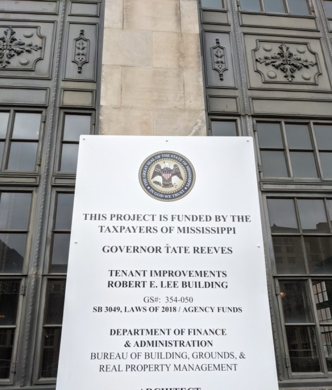
I took a stroll past the old Greyhound station, where a plaque honors the Freedom Riders. I noticed that at the other end of the block a sign announced improvements “…financed by Mississippi Taxpayers” on the Robert E Lee Building. This historic structure was the whites-only Robert E. Lee Hotel until the Civil Rights Act of 1964 passed. The owners decided to shut it down rather than allow black people as guests. Times are changing, but the ghosts of Mississippi’s racist history still haunt Jackson.

I promised myself that I’d return to spend some time at the Civil Rights museum and do my best to meet some locals, but I was racing through Jackson for a good reason. I wanted enough daylight to appreciate my next stop: Poverty Point, Louisiana. This is another Native American archaeological site, one which was never as populous or influential as Cahokia, but a far more ancient and far more mysterious place.
Poverty Point is tucked into the far northeastern corner of Louisiana. Arkansas is to the North and Mississippi to the East. The name of the place tells us that this was an isolated and impoverished part of a poor and sparsely-inhabited region for much of history we know, but three thousand years ago it was a thriving and important center of an ancient civilization. The structures at Poverty Point were built some time between 1650 and 700 BC, not long after the Great Pyramid of Egypt was erected, and before the Mayans began to built theirs.
As I headed West and crossed the big river into Louisiana the landscape was flat and the roads were long and straight, The day was about as warm as my Yankee soul found pleasant ; I couldn’t imagine the brutal heat that summer would bring here. I passed a few scattered clusters of houses, a few small farms, a pecan orchard, and dozens and dozens of small churches. I wondered how such a sparsely populated place could support so many churches.
Poverty point is a UNESCO World Heritage site like Cahokia, but it’s less well known and apparently not visited as often. The sign in the parking lot told me it’s managed as a Louisiana State Park. There was only one other car parked there, probably an employee’s. A few kiosks and informational signs told about the site and led me to the small building housing a modest collection of interpretive exhibits and artifacts. The teenage park employee attending the site seemed bored, and didn’t have answers to my questions about about Poverty Point beyond the location of the trail maps and rest rooms.


But I wasn’t bored. Stepping outside, I was awed. Across from the parking lot was an impressive network of concentric earthen semi-circles nearly a quarter of a mile in diameter, though the pattern of these ridges isn’t obvious at ground level. Diminished by centuries of erosion and a hundred years of plowing and planting, they were only noticed in the 1950s by an archaeologist looking at aerial photographs. The evidence suggestions that this may have been a ritual space or a village, though it may have been something entirely different and unknown to us.
Researchers have found post holes in these rings, spaced in a way that suggests the remains of a Stonehenge-style astronomic observatory, but none of the experts seem confident about this. There’s an impressive 37-acre plaza (also surrounded by massive posts), and six earthen mounds. The biggest, known as “The Bird Mound” is second in size only to Cahokia’s Monk’s Mound.
As you may be starting to notice, we don’t know much about the civilization that built Poverty Point. It was pre-agricultural; a few thousand years would pass before corn made its way here from what we now call Mexico. The nearby villages, scattered in a 100-mile area around the Mississippi river, fished, hunted, and foraged. They didn’t hunt with bows and arrows. The bow and arrow was futuristic technology to these people. They had the atlatl, a throwing stick that could launch a dart or a spear much faster than a human arm. 2.

Creative Commons BY-SA 2.5 License
We can’t call this a “stone age” culture; There weren’t any stones available locally. They did import some from far away and used them for spearheads, tools and jewelry. Digs have turned up thousands of spheres, called “cooking balls” These were fired from clay soil and seem to have been used to boil water or perhaps to heat up underground ovens. There were a few simple clay vessels, but pottery was another unimagined technology of the future for these people.
I wandered the site, enjoying the warm afternoon sunlight, hiking up and down the concentric grooves, which somehow reminded me of half of a vinyl record, each ridge a song, the spaces between providing pauses in the music. Some archaeologists think they used this space for rituals or large sport events, though some say that there were probably homes built on top of the ridges. A marked trail took me a short distance to the place called “Mound A” or “The Bird mound.”
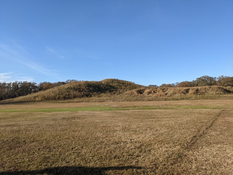
This felt very different from Cahokia. For one thing, I was alone here. The emptiness and quiet made it easy to feel like I was exploring an ancient mystery. Mound A is called the Bird Mound because seen from above, its shaped like the letter T. Many think it forms the outline of a bird in flight, not an uncommon motif among later native cultures. I climbed the stairs on the eastern side, the “tail” of the bird. It’s over 70 feet tall with wings stretching out about ten times the height. Nobody is sure why it was built (it’s not a burial mound), but it must have been a huge effort: over ten million baskets of clay and earth had to be dug up, hefted on to shoulders, carried to the site, and deposited.

Huffing and puffing a bit (all these hours at the wheel, not to mention the Southern cooking, were not helping my aerobic fitness). I looked out across the flat bottom land, enjoying the cool breeze and letting my mind wander. I tried to imagine what life might have been life for the people who lived here and what this place might have meant to them.
The sun was setting by the time I headed down the road. My next stop was Natchez.
- It’s not unusual for big cities to be politically progressive, even in conservative states. Austin (Texas), Salt Lake City (Utah), Nashville (Tennessee), and New Orleans (Louisiana) are all examples of this, but Jackson is an extreme case.
- It may be an ancient, primitive technology, but its an impressive weapon. The armies of Cortez reported that spears launched by Aztecs using an atlatl (an Aztec word) could pierce Spanish armor
Thank you for introducing me to Poverty Point. I had no idea this existed.